


The source of Gokase-river is in the east foot of Mukosaka Mountain,1684m's sea level, which is in the border between prefectures in Miyazaki and Kumamoto. Gokase-river flows into the Pacific Ocean in Nobeoka City through Miyazaki Prefecture Takachiho-cho via the Kumamoto Prefecture Santo-cho. It is an big river in the first-grade river with the fulllength106Km. As for the stratum in Kushu-Sanch,Kyushu-upland, the whole area stands up with the Chichibu band and the status formation which is called in Shimanto Layers for the most part. The big pyroclastic flow in the Aso-san, the Aso volcano, flowed there over four times until about 270,000 years - 90,000 years before.This pyroclastic flow is called Aso-1, Aso-2, Aso-3, Aso-4 from the older one.
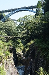
The lodgment of the pyroclastic flow was eroded for many years by the subsoil water on the Aso somma.Then, a terrace surface was formed by the high position.There is a place to exceed 200m. Most of the gorges is formed on the cliff of the columnar-joint. The height cliff of about 150 m continues for several kilometers. We can not see such beautiful scenery in the other place. As for this gorge, by the area, typical one is called " Soyo gorge " "Takachiho-kyo "and so on. The distance of the Gokase canyon is above 100Km including the branch at the whole. This home page classifies Gokase canyon into three areas and guides it including the branch with "Gokase - Soyo area ", " Takachiho area ", " Hinokage - Kitakata area ". Also, it introduces the life and the highlight of the area, too, all together. |
||||||||||||||||||||||


|
|||||
|
|